
Look up any US county's climate zone, see it on the national map, and check whether the 2021 code moved it. The map covers all 3,142 counties in the 50 states and DC, and the 2024 IECC kept the same zones.
Zone 4, Mixed: for example New York City, Seattle.
The US has eight climate zones on the 2021 IECC map, numbered from 1 (very hot, like Miami) to 8 (subarctic, like Fairbanks). Most zones also carry a moisture letter: A for humid, B for dry, C for marine. Each county gets one zone from its heating and cooling degree days, and 4A covers the most counties: 718 of 3,142.
The 2021 IECC climate zone map
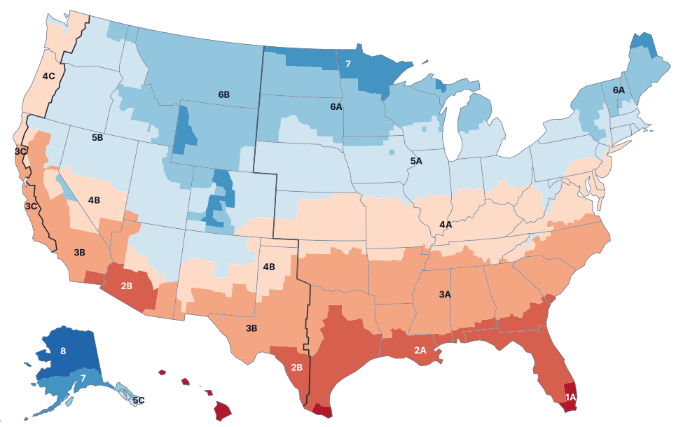
- 1 Very Hot
- 2 Hot
- 3 Warm
- 4 Mixed
- 5 Cool
- 6 Cold
- 7 Very Cold
- 8 Subarctic
Thick lines: borders between humid (A), dry (B) and marine (C) areas.
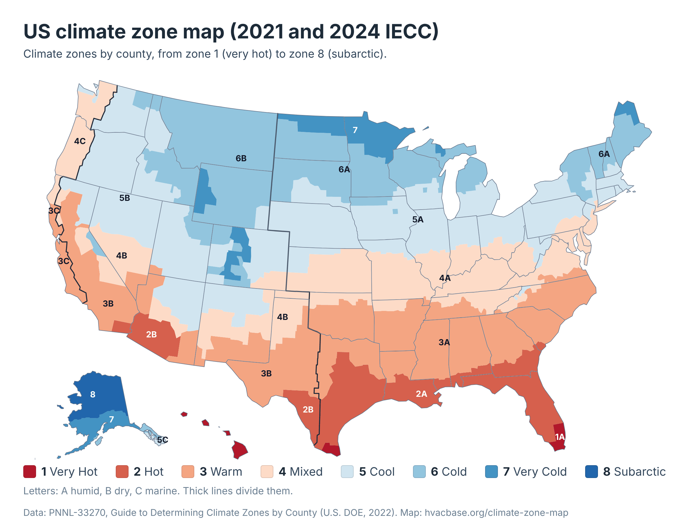
Red is hot and blue is cold. Zone 1 covers south Florida, the Rio Grande Valley in Texas and all of Hawaii, and zone 8 covers interior and northern Alaska.
The thick dark lines separate humid (A) country in the East from dry (B) country in the West and the marine (C) strip on the Pacific side. Download the full-size map (PNG).
US climate zones 1 to 8 at a glance
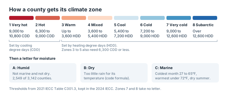
Each zone number comes from degree days: how far a place's daily average temperature sits above or below a base temperature, added up over a year. Zones 1 and 2 are defined by cooling degree days above 50°F, and zones 3 to 8 by heating degree days below 65°F. Zones 3 to 5 also have to stay at or under 6,300 cooling degree days.
CDD: cooling degree days above 50°F. HDD: heating degree days below 65°F. Definitions: 2021 IECC Table C301.3.
| Zone | Name | Definition | Codes in use | Example places | Counties |
|---|---|---|---|---|---|
| 1 | Very Hot | 9,000 to 10,800 CDD | 1A (12) | Miami, Honolulu | 12 |
| 2 | Hot | 6,300 to 9,000 CDD | 2A (239), 2B (20) | Houston, Phoenix | 259 |
| 3 | Warm | Up to 3,600 HDD, and 6,300 CDD or less | 3A (637), 3B (110), 3C (14) | Atlanta, Las Vegas | 761 |
| 4 | Mixed | 3,600 to 5,400 HDD, and 6,300 CDD or less | 4A (718), 4B (66), 4C (34) | New York City, Seattle | 818 |
| 5 | Cool | 5,400 to 7,200 HDD, and 6,300 CDD or less | 5A (637), 5B (146), 5C (7) | Chicago, Denver | 790 |
| 6 | Cold | 7,200 to 9,000 HDD | 6A (306), 6B (119) | Minneapolis, Billings | 425 |
| 7 | Very Cold | 9,000 to 12,600 HDD | 7 (69) | Duluth, Anchorage | 69 |
| 8 | Subarctic | Over 12,600 HDD | 8 (8) | Fairbanks | 8 |
What the A, B and C mean
The letter after the number describes moisture. The code defines marine and dry by formula and calls everything else humid:
- A, humid: anywhere that isn't marine or dry. It's the most common letter, on 2,549 of the 3,142 counties.
- B, dry: too little precipitation for the local temperature, judged by a formula in the code. The 461 B counties run across the West, from west Texas to Montana and eastern Washington.
- C, marine: a coldest month between 27°F and 65°F, a warmest month under 72°F, at least four months above 50°F, and a dry summer. Only 55 counties qualify, in coastal California, western Oregon and Washington, and Southeast Alaska.
Zones 7 and 8 take no letter. The letter feeds our dehumidifier cost calculator: humid zones 1 to 3 raise its estimate and dry B zones lower it.
Zone by zone
Zone 1: very hot
Only 12 counties are zone 1, all humid (1A): the five counties of Hawaii, four in south Florida (Miami-Dade, Broward, Palm Beach and Monroe) and three in the Rio Grande Valley of Texas (Cameron, Hidalgo and Willacy). Palm Beach and the three Texas counties joined zone 1 in 2021. The zone is defined by cooling alone, 9,000 to 10,800 cooling degree days, and our BTU calculator gives it the largest cooling allowance per square foot.
Zone 2: hot
Zone 2 has 259 counties in nine states. Humid 2A runs along the Gulf Coast and covers most of Florida, with Texas (81 counties), Florida (63), Georgia (41) and Louisiana (37) holding most of them; Houston is 2A.
Dry 2B has 20 counties in southern Arizona (including Phoenix and Tucson), southwest Texas (including Laredo) and California's Imperial County. In 2021, 21 counties moved from 3A into 2A, among them Dallas County, Texas.
Zone 3: warm
Zone 3 has 761 counties in 17 states. Humid 3A covers most of the Southeast, led by Georgia (118 counties), North Carolina (79) and Mississippi (76), and includes Atlanta.
Dry 3B takes in west Texas and much of inland California, including Los Angeles and Sacramento, plus Las Vegas. Marine 3C is 14 counties on the California coast, including San Francisco.
In 2021, 97 counties moved from 4A into 3A, mostly in North Carolina, Georgia, Tennessee and Virginia, while 15 Oklahoma counties went the other way, from 3A to 4A.
Zone 4: mixed
Zone 4 is the largest zone, with 818 counties in 26 states, and 4A alone covers 718 of them. All 120 of Kentucky's counties are 4A, and Virginia (110), Kansas and Missouri (87 each) follow; New York City is 4A too.
Dry 4B has 66 counties, from the Texas Panhandle through New Mexico to Nevada and California. Marine 4C covers western Oregon and Washington, including Seattle.
In 2021, 67 counties moved from 5A into 4A, including Franklin County, Ohio (Columbus).
Zone 5: cool
Zone 5 reaches more states than any other: 33, with 790 counties. Humid 5A spans the Midwest and the Northeast, from Nebraska (93 counties) and Iowa (84) to Pennsylvania and Massachusetts, and includes Chicago.
Dry 5B covers the Intermountain West, including Denver, and marine 5C is seven counties in western Washington and Southeast Alaska. In 2021, 82 counties moved from 6A to 5A, 30 of them in Wisconsin, including Milwaukee County.
Zone 6: cold
Zone 6 has 425 counties in 18 states. Humid 6A covers the upper Midwest and northern New England: Minnesota (61 counties), South Dakota (48), Michigan (44) and Wisconsin (42), plus Vermont, where all 14 counties are 6A. Minneapolis is 6A.
Dry 6B covers the northern Rockies, and all 56 of Montana's counties are 6B. In 2021, 52 counties moved from 7 to 6A, including Cass County, North Dakota (Fargo).
From zone 6 north, our heat pump calculators assume a cold-climate heat pump.
Zone 7: very cold
Zone 7 has 69 counties in seven states: Minnesota (23), North Dakota (16), Colorado (13), Wyoming (3), Michigan's Keweenaw and Marquette counties, Maine's Aroostook County, and 11 areas of Alaska, including Anchorage. Duluth is zone 7.
Zone 8: subarctic
Zone 8 is eight areas of interior, northern and western Alaska: Denali, Fairbanks North Star, Kusilvak, Nome, North Slope, Northwest Arctic, Southeast Fairbanks and Yukon-Koyukuk. Its threshold is more than 12,600 heating degree days a year. Three Alaska areas (Aleutians West, Bethel and Dillingham) moved from 8 to 7 in 2021.
Climate zones by state
Zone lines follow county lines, so most states span more than one zone. California has the most zone codes (seven) and Texas has six. Nine states and DC sit in a single zone: Connecticut, Massachusetts, Nebraska and Rhode Island (5A), Delaware, Kentucky and DC (4A), Vermont (6A), Montana (6B) and Hawaii (1A).
| State | Zone codes (counties) | Most common | Changed in 2021 |
|---|---|---|---|
| Alabama | 3A (58), 2A (9) | 3A | 7 |
| Alaska | 7 (11), 8 (8), 6A (7), 5C (3) | 7 | 14 |
| Arizona | 2B (5), 3B (5), 5B (3), 4B (2) | 2B | 0 |
| Arkansas | 3A (63), 4A (12) | 3A | 0 |
| California | 3B (25), 3C (14), 4B (8), 5B (6), 4C (2), 6B (2), 2B (1) | 3B | 0 |
| Colorado | 5B (34), 7 (13), 6B (12), 4B (5) | 5B | 3 |
| Connecticut | 5A (8) | 5A | 0 |
| Delaware | 4A (3) | 4A | 0 |
| District of Columbia | 4A (1) | 4A | 0 |
| Florida | 2A (63), 1A (4) | 2A | 1 |
| Georgia | 3A (118), 2A (41) | 3A | 28 |
| Hawaii | 1A (5) | 1A | 0 |
| Idaho | 5B (22), 6B (22) | 5B | 0 |
| Illinois | 5A (58), 4A (44) | 5A | 6 |
| Indiana | 5A (47), 4A (45) | 5A | 15 |
| Iowa | 5A (84), 6A (15) | 5A | 25 |
| Kansas | 4A (87), 5A (18) | 4A | 9 |
| Kentucky | 4A (120) | 4A | 0 |
| Louisiana | 2A (37), 3A (27) | 2A | 0 |
| Maine | 6A (15), 7 (1) | 6A | 0 |
| Maryland | 4A (22), 5A (2) | 4A | 1 |
| Massachusetts | 5A (14) | 5A | 0 |
| Michigan | 6A (44), 5A (37), 7 (2) | 6A | 12 |
| Minnesota | 6A (61), 7 (23), 5A (3) | 6A | 10 |
| Mississippi | 3A (76), 2A (6) | 3A | 1 |
| Missouri | 4A (87), 5A (26), 3A (2) | 4A | 6 |
| Montana | 6B (56) | 6B | 0 |
| Nebraska | 5A (93) | 5A | 0 |
| Nevada | 5B (9), 4B (7), 3B (1) | 5B | 7 |
| New Hampshire | 5A (5), 6A (5) | 5A | 1 |
| New Jersey | 4A (13), 5A (8) | 4A | 0 |
| New Mexico | 4B (13), 5B (12), 3B (8) | 4B | 2 |
| New York | 5A (36), 6A (18), 4A (8) | 5A | 8 |
| North Carolina | 3A (79), 4A (16), 5A (5) | 3A | 34 |
| North Dakota | 6A (37), 7 (16) | 6A | 14 |
| Ohio | 5A (64), 4A (24) | 5A | 15 |
| Oklahoma | 3A (59), 4A (15), 4B (3) | 3A | 15 |
| Oregon | 4C (18), 5B (18) | 4C | 0 |
| Pennsylvania | 5A (53), 4A (14) | 5A | 16 |
| Rhode Island | 5A (5) | 5A | 0 |
| South Carolina | 3A (44), 2A (2) | 3A | 2 |
| South Dakota | 6A (48), 5A (18) | 6A | 5 |
| Tennessee | 4A (61), 3A (34) | 4A | 22 |
| Texas | 2A (81), 3B (70), 3A (58), 4B (28), 2B (14), 1A (3) | 2A | 8 |
| Utah | 5B (21), 6B (7), 3B (1) | 5B | 3 |
| Vermont | 6A (14) | 6A | 0 |
| Virginia | 4A (110), 3A (19), 5A (4) | 4A | 23 |
| Washington | 5B (18), 4C (14), 5C (4), 6B (3) | 5B | 5 |
| West Virginia | 4A (36), 5A (19) | 4A | 9 |
| Wisconsin | 6A (42), 5A (30) | 6A | 45 |
| Wyoming | 6B (17), 5B (3), 7 (3) | 6B | 1 |
California's own energy code works differently: the California Energy Commission divides the state into 16 building climate zones for Title 24, separate from this map.
What changed in 2021
The 2021 IECC was the first edition to redraw the map since the 2004 supplement. ASHRAE updated the zones using NOAA records from more than 4,000 weather stations and published them in Standard 169-2013, and the 2021 IECC adopted them. The 2024 IECC kept the same zones.
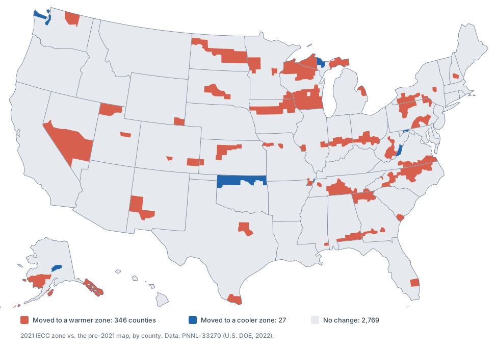
373 of the 3,142 counties changed zone, about 12%. 346 moved to a warmer, lower-numbered zone and 27 to a cooler one, and counties in 33 states were affected.
| Change | Counties | Top states |
|---|---|---|
| 4A → 3A | 97 | NC 33, GA 22, TN 21, VA 19 |
| 6A → 5A | 82 | WI 30, IA 25, NY 8, PA 8 |
| 5A → 4A | 67 | IN 15, OH 15, KS 9, WV 9 |
| 7 → 6A | 52 | WI 15, ND 14, MI 9, AK 7 |
| 3A → 2A | 21 | AL 7, GA 6, TX 5, SC 2 |
| 3A → 4A | 16 | OK 15, TN 1 |
| 5B → 4B | 10 | NV 7, CO 2, NM 1 |
| 6B → 5B | 6 | UT 3, CO 1, WA 1, WY 1 |
| 4A → 5A | 5 | VA 4, MD 1 |
| 2A → 1A | 4 | TX 3, FL 1 |
| 4C → 5C | 4 | WA 4 |
| 8 → 7 | 3 | AK 3 |
| 7 → 5C | 3 | AK 3 |
| 7 → 8 | 1 | AK 1 |
| 6A → 7 | 1 | MI 1 |
| 4B → 3B | 1 | NM 1 |
Some of the larger counties that moved:
- Dallas County, Texas: 3A to 2A
- Wake County, North Carolina (Raleigh): 4A to 3A
- Davidson County, Tennessee (Nashville): 4A to 3A
- Franklin County, Ohio (Columbus): 5A to 4A
- Milwaukee County, Wisconsin: 6A to 5A
- Cass County, North Dakota (Fargo): 7 to 6A
- Palm Beach County, Florida: 2A to 1A
Moves to a cooler zone were rare: 15 Oklahoma counties went from 3A to 4A, five counties in Virginia and Maryland from 4A to 5A, and four Washington counties (Clallam, Island, Kitsap and San Juan) from 4C to 5C.
The ICC's commentary on the code notes that moving counties to warmer zones lessens their energy-efficiency requirements until the efficiency provisions themselves are revised. Which map applies to a building project depends on the code edition your state or city has adopted, and editions from the 2004 supplement through 2018 used the earlier map. The lookup at the top of this page shows your county's zone on both.
How your zone changes HVAC sizing
Every calculator on this site that asks for a climate uses the zone. The figures below are our calculators' assumptions, not code values, and they move one way: the hotter the zone, the more cooling per square foot, and the colder, the more heating.
| Zone | Room AC allowance (BTU/sq ft) | AC tonnage factor | Heating degree days assumed | Heat pump assumption |
|---|---|---|---|---|
| 1Very Hot | 32 | 1.40 | 400 | Very hot |
| 2Hot | 30 | 1.20 | 1,500 | Hot |
| 3Warm | 28 | 1.10 | 2,700 | Hot |
| 4Mixed | 22 | 1.00 | 4,500 | Mixed |
| 5Cool | 20 | 0.90 | 6,500 | Cold |
| 6Cold | 18 | 0.85 | 8,000 | Very cold, cold-climate model |
| 7Very Cold | 16 | 0.80 | 10,800 | Very cold, cold-climate model |
| 8Subarctic | 14 | 0.80 | 12,600 | Very cold, cold-climate model |
Calculator assumptions, not code values.
- Air conditioner BTU calculator: sizes a room or window unit.
- AC tonnage calculator: sizes central air for a whole house.
- Furnace sizing calculator: sizes a gas furnace and estimates its yearly gas cost.
- Heat pump size calculator: uses the Building America region shown in your result.
- Furnace vs. heat pump: in our model the heat pump costs less to run only in zone 1, and it emits less carbon through zone 4.
- Insulation R-value guide: ENERGY STAR recommends R-30 to R-49 for an uninsulated attic in zone 1 and R-60 in zones 4 through 8.
Not the same as USDA growing zones
If you're choosing plants, you want a different map. The USDA Plant Hardiness Zone Map is based on the average annual extreme minimum winter temperature, in 10°F zones and 5°F half zones, and its current edition is from 2023. This page is the building-code map, used for insulation, windows and heating and cooling equipment.
The numbers don't correspond: zone 5 here says nothing about hardiness zone 5. Köppen-Geiger maps, common in geography, are a third system that classifies climates worldwide by temperature and rainfall.
Frequently asked questions
What climate zone am I in?
Tap Find my zone at the top of this page, or pick your state and county. Zones follow county lines, so everyone in a county shares one zone. For a quick check without the tool, find your state in the climate zones by state table.
How many climate zones are there in the US?
Eight, numbered 1 (very hot) to 8 (subarctic). With the moisture letters, 16 zone codes are in use across the 50 states and DC. The code also defines a zone 0 for the hottest places in the world, but no county in the 50 states or DC falls in it.
What does climate zone 4A mean?
Zone 4 (mixed) with a humid moisture regime: 3,600 to 5,400 heating degree days a year and no more than 6,300 cooling degree days. It's the most common code in the country, covering 718 counties, including New York City.
What does climate zone 5A mean?
Zone 5 (cool) with a humid moisture regime: 5,400 to 7,200 heating degree days a year and no more than 6,300 cooling degree days. It covers 637 counties across the Midwest and Northeast, including Chicago.
What is climate zone 7?
The very cold zone: 9,000 to 12,600 heating degree days a year, with no moisture letter. It covers 69 counties in Minnesota, North Dakota, Colorado, Wyoming, Michigan, Maine and Alaska, including Duluth and Anchorage.
Is the ASHRAE climate zone map the same as the IECC map?
They share a source. The 2021 IECC zones are based on ASHRAE Standard 169-2013, Climatic Data for Building Design Standards, and the 2024 IECC kept them.
Did climate zones change in 2021?
Yes. 373 counties changed zone, 346 of them to a warmer one. Look up your county with the tool at the top of this page: when its zone changed, the result shows the old zone too.
What climate zone is Alaska? What about Hawaii?
Hawaii is all zone 1A. Alaska spans four zones: 5C and 6A in the southeast panhandle and on Kodiak Island, 7 across the south and southwest including Anchorage, and 8 in the interior, the north and parts of the west coast, including Fairbanks.
Is a climate zone the same as a growing zone?
No. Growing zones come from the USDA Plant Hardiness Zone Map, which uses the average annual extreme minimum winter temperature. Building climate zones come from heating and cooling degree days plus moisture.
Why does my climate zone matter for HVAC?
The IECC uses it to set the energy requirements that apply to a building, such as insulation and window levels. Our sizing and cost calculators use it too: hotter zones get more cooling per square foot, colder zones get more heating, and zones 6 to 8 assume a cold-climate heat pump.
About the data
Zones come from the county data files for PNNL-33270, the Pacific Northwest National Laboratory's guide to climate zones by county for the U.S. Department of Energy (September 2022). We downloaded them on October 15, 2026 and checked them against the county tables printed in the report. Puerto Rico isn't included: its municipios carry no zone values in the data.
Sources & References
- PNNL: Guide to Determining Climate Zones by County: Building America and IECC 2021 Updates (PNNL-33270, 2022)
- Building America Solution Center: climate zone county data files
- ICC: 2021 IECC Code and Commentary, Chapter 3 [CE] (sample chapter)
- ICC: 2024 IECC Code and Commentary, Chapter 3 [CE] (sample chapter)
- USDA: 2023 Plant Hardiness Zone Map
- California Energy Commission: California Building Climate Zones
Related Articles
Insulation R-Value Guide: Recommended Levels by Climate Zone (2026)
Guide • 8 min read
AC Tonnage Calculator Per Square Foot (+Sizing Chart) 2026
Calculator • 12 min read
Furnace Size Calculator: What Size Furnace Do I Need? (2026)
Calculator • 10 min read
Heat Pump Size Calculator: What Size Heat Pump Do I Need? (2026)
Calculator • 8 min read
Furnace vs Heat Pump: Which Is Better? (2026 Cost and Climate Comparison)
Comparison • 6 min read